Latest Maps Near Essex County
VIMS jellyfish map for today, Essex County
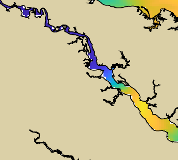
 Low
Low
NOAA Rappahannock River jellyfish map for today, Essex County
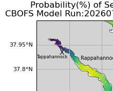
 Low
Low
Recent Trend in Essex County
Jellyfish chances are about the same as yesterday (14%). Over the past week, jellyfish have mostly stayed away from this area.
Essex County Jellyfish Conditions
For Essex County, jellyfish look light today. The highest of the latest NOAA and VIMS model readings is 14%. Tomorrow looks light, around 14%. The five-day VIMS outlook looks about the same, around 13%.
Jellyfish are more likely here than in most Virginia places we check today. Jellyfish can vary here, so today's map matters more than a rule of thumb. For this page, we check Rappahannock River using NOAA Rappahannock River plus VIMS broad map.
Popular beach and water-access searches around Essex County include Tappahannock Waterfront, Duke Street Beach, and Marsh Street Beach. People often check this page for searches like Essex County jellyfish report, Tappahannock Waterfront jellyfish, and Rappahannock River jellyfish conditions.
Popular Beaches and Water Access in Essex County
- Tappahannock Waterfront Light on Rappahannock River: Rappahannock River waterfront area and common Essex County search target for local river conditions.
- Duke Street Beach Light on Rappahannock River: Small town beach at the end of Duke Street on Tappahannock's Rappahannock River waterfront. Official info.
- Marsh Street Beach Light on Rappahannock River: Small town beach at the end of Marsh Street on Tappahannock's Rappahannock River waterfront. Official info.
Nearby Jellyfish Reports
If you are deciding where to go, these nearby Virginia reports are worth checking too.
- Richmond County jellyfish report
- Middlesex County jellyfish report
- Lancaster County jellyfish report
- Westmoreland County jellyfish report
The maps above are the latest VIMS and NOAA guidance we have for this area. We save each day's reading so this report can get more useful over time.
About Rappahannock River jellyfish
The Rappahannock is a river where sea nettles are often active in summer, especially in the saltier lower river toward the Northern Neck and the bay. NOAA runs a dedicated Rappahannock sea nettle forecast for this reason. Upstream toward Fredericksburg the water is usually too fresh.
Beach Bag Sting Kit
A few simple items make a jellyfish sting easier to handle and less likely in the first place. We haven't lab-tested these ourselves — these are the picks that came out on top when we compared reviews, reputations, and Amazon track records. Here is what we suggest keeping in the beach bag during sea nettle season.
-
Sting relief gel
After Bite Xtra is the pharmacist-recommended favorite in sting-treatment roundups, with a gentle diphenhydramine formula for the burn and itch once you are out of the water.
Buy the After Bite Xtra on Amazon -
Small vinegar bottle
There's no jellyfish-specific vinegar bottle out there, so we like a small leak-proof silicone travel bottle (humangear GoToob+) you fill yourself — handy for beaches where local guidance calls for vinegar, though it's not a clear win for bay sea nettles.
Buy the GoToob+ bottle on Amazon -
Rash guard
O'Neill's Basic Skins UPF 50+ long-sleeve is the name that keeps coming up as the reliable no-frills pick for covering skin that sea nettles would otherwise reach — just size up, reviewers say it runs a little small.
Buy the O'Neill Basic Skins rash guard on Amazon Browse more rash guards -
Water shoes
The Speedo Tidal Cruiser is the well-reviewed, widely available pick for keeping feet protected from stings and shells in shallow water. (Speedo discontinued the older Surfwalker Pro 3.0, so this is its current equivalent.)
Buy the Speedo Tidal Cruiser on Amazon Browse more water shoes -
Tweezers and first-aid kit
The Coleman All-Purpose Mini First Aid Kit is a genuine Amazon best-seller with metal tweezers included, small enough to live in a beach bag year-round.
Buy the Coleman mini first-aid kit on Amazon -
Reef-safe sunscreen
Badger's Sport Mineral Sunscreen SPF 40 is a repeat top pick in reef-safe roundups — a simple, non-nano zinc formula with no oxybenzone or octinoxate.
Buy the Badger mineral sunscreen on Amazon -
Waterproof phone pouch
The Hiearcool 2-pack is an Amazon best-seller for a reason — tens of thousands of ratings at 4.6 stars for an IPX8 pouch that still lets you use your touchscreen at the water's edge.
Buy the Hiearcool phone pouch on Amazon -
Beach umbrella
The Sport-Brella Super-Brella is the recurring 'best overall' pick in shade-umbrella roundups, with vents, stakes, and tethers included to help it hold up in a stiff bay breeze.
Buy the Sport-Brella canopy on Amazon
As an Amazon Associate I earn from qualifying purchases. This site may earn a commission from qualifying purchases made through these links, at no extra cost to you.
Essex County Jellyfish FAQ
Are there jellyfish in Essex County today?
Essex County currently shows light jellyfish conditions, a 14% chance of encountering stinging jellyfish as of 2026-10-11.
Where can you swim in Essex County?
Popular swimming and water access spots in Essex County include Tappahannock Waterfront, Duke Street Beach, and Marsh Street Beach.
When are jellyfish worst in Essex County?
Jellyfish can vary here, so today's map matters more than a rule of thumb. In Virginia and the Chesapeake Bay, jellyfish are typically most common from mid-summer through early fall, when the water is warmest.
Source maps are model guidance from VIMS and NOAA/NCCOS. They are useful for a quick beach check, but they do not count jellyfish in the water and may not match conditions at every shoreline. Always check conditions when you arrive: posted lifeguard flags beat any forecast, and a purple flag means dangerous marine life has actually been seen, whatever the model says.